Snowpack Update 12/6/22
Oh what a sierra storm can do! In less than 7 days, the Tahoe area has received nearly 5 feet of new snow at the upper elevations and the coverage is awesome. The skiing has been incredible, and it’s only December 6! We’re still sticking to low angle slopes as there’s lots of uncertainty in our snowpack, but it is time to get out there and move those legs uphill and down.
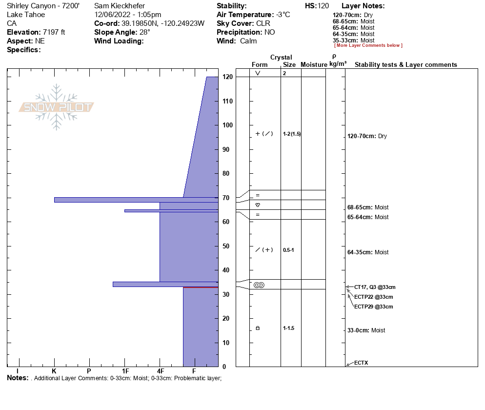
After a couple days of storm skiing and putting in some vertical gain, we opted to give our legs a rest and re-visit the Dec. 1 weak layer following a stormy weekend. We went on a short tour yesterday, digging snow pits at 6700′ and 7200′.
To re-cap, early November snow sat on the ground and cold temps in late November caused this shallow snowpack to facet, making for a weak structure. On December 1, this layer was buried by 13-20″ of new snow. (When we give a problem layer a date, we use the day that layer is buried.) December 2 remained clear before precipitation returned to the area on Dec. 3. Snow levels fluctuated between 7,000′ and 7,500′ for most of the day before dropping below lake level in the early morning hours of December 4. This storm took its time, and finally moved out in the evening of Dec. 5. Above the snow line, 32″ of snow fell during this 3-day period. Below 7,000′, a modest (by Sierra standards) 9-18″ of snow capped off the storm.
So what did this storm (both rain and snow) do to our snowpack? Reports above 7,500′ are that moisture did not reach the buried facets at the base of our snowpack, and with close to 3′ of additional snow added to a weak foundation, considerable hazard remains. This weak layer has been identified on all aspects, but is most widespread on Northwest, North, Northeast and East aspects. Between the additional load from the weekend’s storm and more snow in the forecast, we certainly have pause about traveling in and around avalanche terrain at these elevations, especially on the aspects mentioned above.
Below 7,500′ is where this problem gets a bit more difficult to assess. While there are indications that this layer has just begun to gain strength, we still have a high degree of uncertainty and it’s important to avoid making any assumptions or decisions until more information can be gathered. Because Saturday’s rain has percolated through the snowpack to the ground, and we found this weak layer to be moist at both 6,700′ and 7,200′, the foundation of our snowpack will gain strength.

Test results continue to show both the collapse and propagation of this weak layer, but it’s not as “touchy” as it was prior to the rain event. On the flip side, this weak layer is now buried by more snow and denser snow. While this persistent problem seems to be less touchy than it was on Friday, and signs are pointing towards strengthening, the consequences of an avalanche have increased due to the depth of our snowpack and the density of the snow that sits above the weak layer.In short, lots of uncertainty remains and extreme caution should be exercised when heading into the backcountry. Persistent problems lay below the surface of the snowpack, and while signs of instability like whumpfs and shooting cracks point to this problem, they are no guarantee. It’s not uncommon for the first sign of persistent slab avalanche to be the avalanche itself.
Fortunately, with appropriate terrain selection, endless backcountry skiing can be had in the Tahoe area, and the skiing and riding is quite good right now. If you’re eager to get out into the backcountry, consider hiring an Alpenglow guide to help you find the goods!
Check out Sam’s video on the state of the snowpack!